G-882 Magnetómetro Marino
El Magnetómetro Marino G-882 de Geometrics es el sistema marino líder en la industria con más de 1000 sistemas vendidos en todo el mundo. El G-882 es el único sistema que cumple con los estándares requeridos para la limpieza de UXO en el Mar del Norte.
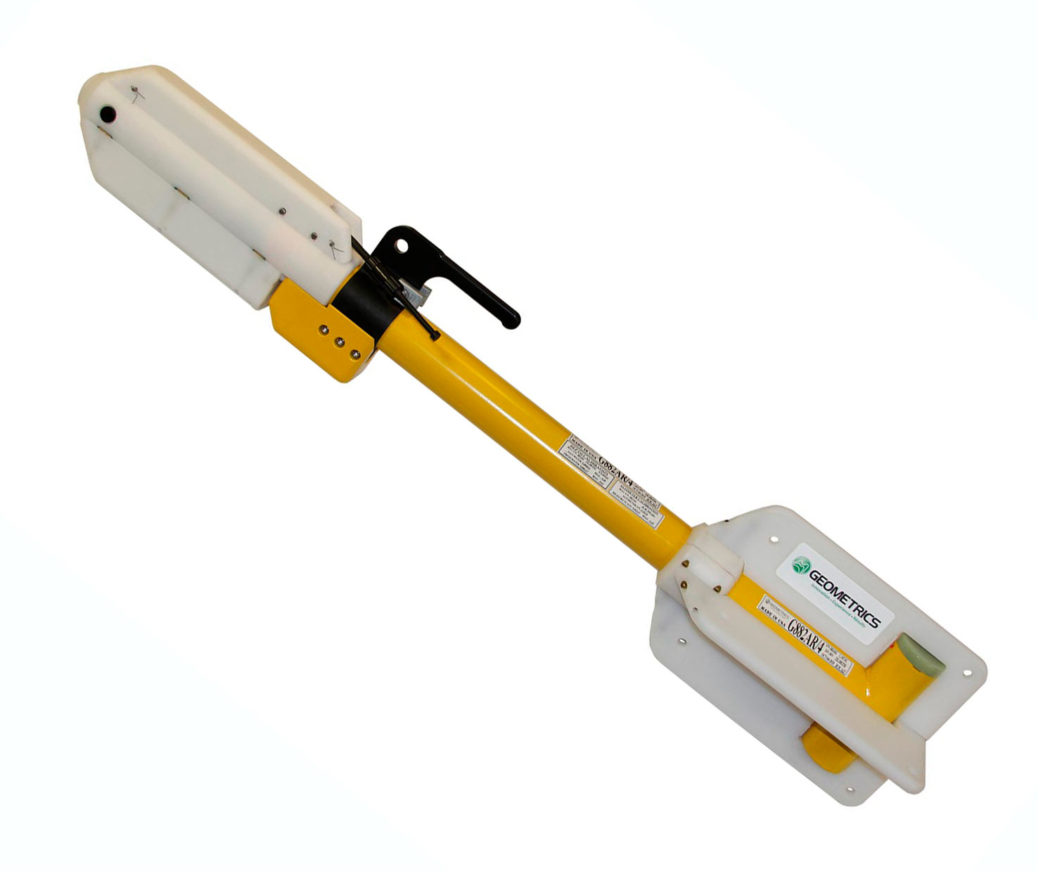
Magnetómetro Marino G-882
Este magnetómetro marino de vapor de cesio de muy alta resolución tiene un bajo costo, un tamaño pequeño y ofrece flexibilidad para estudios profesionales en aguas poco profundas o profundas. Use su ordenador personal con nuestro software MagLog™ para registrar, mostrar e imprimir la posición GPS y los datos del campo magnético. El sistema se conecta directamente a todos los principales fabricantes de sónares de barrido lateral para configuraciones de remolque en tándem. Siendo pequeño y ligero, es fácilmente desplegable y operado por una sola persona. Agregue varios collares de peso aerodinámicos y el sistema puede pesar rápidamente más de 100 lb para aplicaciones de remolque profundo.
Características y beneficios
- Alto rendimiento de vapor de cesio: El rango de detección más alto y una alta probabilidad de detectar todos los objetivos ferrosos de tamaño.
- Diseño aerodinámico para la seguridad del remolque: Baja probabilidad de enredarse en líneas de pesca o rocas. Carcasa de fibra de vidrio resistente.
- Muestreo de hasta 20Hz: Densidad de datos inigualable mientras se cubren áreas más grandes por día.
- El sensor se puede rotar para una señal óptima: Se puede usar en todo el mundo.
- Fácil portabilidad y manejo: No se requiere cabrestante. Asa de fácil transporte incorporada. Operable por una sola persona; solo 44 lb con cable de 200 pies.
- Mini-contador CM-221 interno: Este pequeño contador proporciona sincronización de múltiples sensores y concatenación de datos, lo que permite al usuario combinar múltiples sistemas para una mayor cobertura.
- Versión de exportación disponible: Úselo en cualquier parte del mundo sin necesidad de una licencia de exportación (excepto países embargados). Consulte las especificaciones.
Especificaciones técnicas
G-882 Marine Magnetometer
Software: MagLogLite™ Data Logging software, purchased separately, allows recording and display of data and position with automatic anomaly detection. Additional software options include: MagLog Pro™, advanced logging software; MagMap™, a plotting and contouring package; and MagPick™ post-acquisition processing software.MAGNETOMETER / ELECTRONICS
- Operating Principle: Self-oscillating split-beam Cesium vapor (non-radioactive).
- Operating Range: 20,000 to 100,000 nT.
- Operating Zones: The earth’s field vector should be at an angle greater than 10° from the sensor’s equator and greater than 6° away from the sensor’s long axis. Automatic hemisphere switching.
- Noise: <0.004 nT/ Hzrms. (SX (export) version: <0.02 nT/ Hzrms).
- Max Sample Rate: 20 Hz.
- Heading Error: < 1 nT (over entire 360° spin).
- Output: RS-232 at 1,200 to 19,200 Baud.
- Power: 24 to 32 VDC, 0.75 A at power-on and 0.5 A thereafter.
MECHANICAL
Sensor Fish- DIA: 7 cm; L: 137 cm (2.75x54 in) (with fin assembly).
- Weight: 18 kg (40 lb).
- Includes sensor and electronics and 1 main weight. Additional collar weights are 6.4 kg (14 lb) each; total of 5 capable.
- DIA: 12 mm; L: 800 m (0.47 in x 2,625 ft).
- Weight: 7.7 kg (17 lb) with terminations.
- Break strength: 1,630 kg (3,600 lb).
- Bend diameter: 30 cm (12 in).
ENVIRONMENTAL
- Operating Temperature: -35°C to +50°C (-30°F to +122°F).
- Storage Temperature: -45°C to +70°C (-48°F to +158°F).
- Altitude: 9,000 m (30,000 ft).
- Depth: 4,000 psi (2,730 m; 8956 ft).
- Water Tight: O-Ring sealed for up to 4,000 psi depth operation.
ACCESSORIES
- Standard: Operation manual, shipping/storage container, ship kit with tools and hardware, power supply, MagLogLiteTM, MagMapTM and MagPickTM processing software, depth transducer, altimeter.
- Optional: Steel tow cable to 6,000 m (19,600 ft) with telemetry, longitudinal or transverse gradiometer, plastic Pelican® case, MagLogProTM, collar weights.
Typical Detection Range for Common Objects
- Ship: 1000 tons 0.5 to 1 nT at 800 ft (244 m)
- Anchor: 20 tons 0.8 to 1.25 nT at 400 ft (120 m)
- Automobile: 1 to 2 nT at 100 ft (30 m)
- Light Aircraft: 0.5 to 2 nT at 40 ft (12 m)
- Pipeline (12 inch): 1 to 2 nT at 200 ft (60 m)
- Pipeline (6 inch): 1 to 2 nT at 100 ft (30 m)
- Iron: 100 kg 1 to 2 nT at 50 ft (15 m)
- Iron: 100 lb 0.5 to 1 nT at 30 ft (9 m)
- Iron: 10 lb 0.5 to 1 nT at 20 ft (6 m)
- Iron: 1 lb 0.5 to 1 nT at 10 ft (3 m)
- Screwdriver: 5-inch 0.5 to 2 nT at 12 ft (4 m)
- Bomb: 1000 lb 1 to 5 nT at 100 ft (30 m)
- Bomb: 500 lb 0.5 to 5 nT at 50 ft (16 m)
- Grenade: 0.5 to 2 nT at 10 ft (3 m)
- Shell: 20 mm 0.5 to 2 nT at 5 ft (1.8 m)
An Important Note About Altimeters
Geometrics recommends that customers purchase the G-882 and altimeter together from Geometrics to ensure full factory testing and compatibility.
G-882 TVG Information
Geometrics’ model G-882TVG Transverse Gradiometer system is an advanced integrated magnetometer system providing unmatched versatility and performance. It has a 1.5m-wide sensor separation for maximum target detection efficiency and survey cost effectiveness.
Shipping Weights & DIMS |
||
|---|---|---|
| Contents | Dimensions (L x W x H) | Weight |
| Case 1 - G-882 Marine Magnetometer | 66in x 16in x 15in 168cm x 41cm x 38cm | 148lbs 67kg |
- Detection and Mapping of ferrous objects: Ferrous objects of all sizes, such as anchors, chains, cables, pipelines, ballast stones and other scattered shipwreck debris, munitions of all sizes (UXO), aircraft, engines and any other object with a magnetic expression.
- Geologic Studies: Characterize the magnetic signature of the Earth over vast distances for geologic studies